
Tobabe Sandstone Fm
Type Locality and Naming
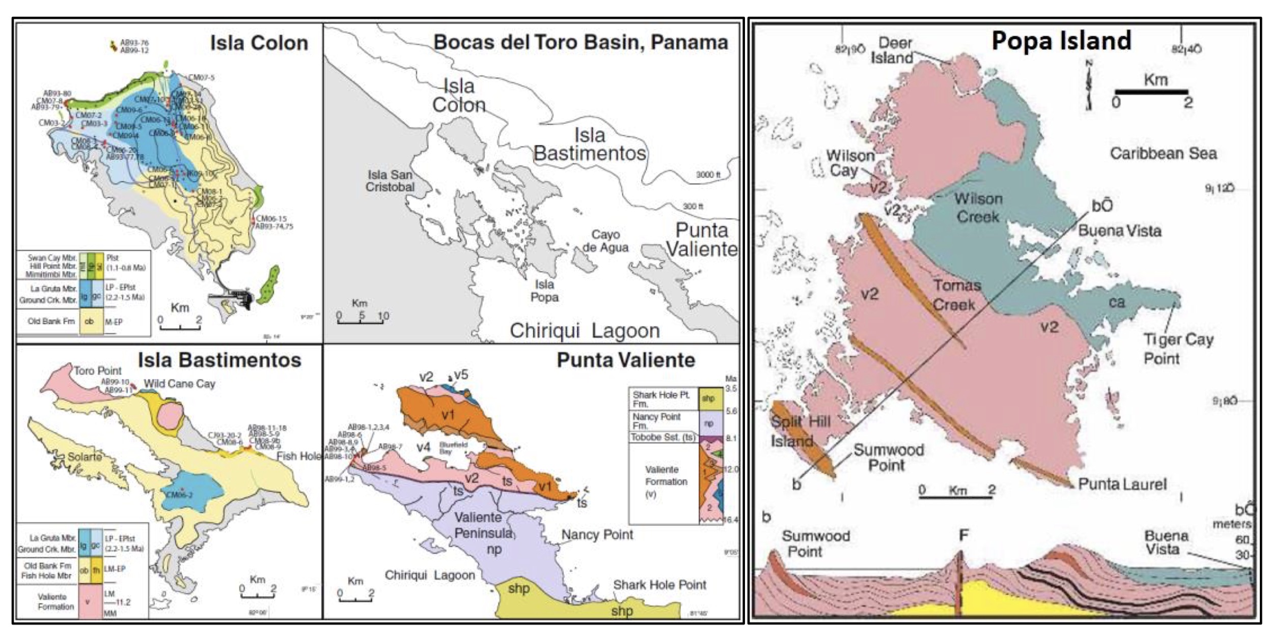
[Figure 1. Bocas del Toro archipelago, NW Panama with map of the western & central portion together with the geological maps of Isla Colon, Isla Bastimentos, Punta Valiente (Klaus et al. (2012)) and Popa Island (Coates et al. (2005)). Section (b-b’) over Popa Island shows the Valiente Fm where it is unconformably overlain by the Pliocene Cayo Agua Fm. On Popa Island, only the v1 basalt flow facies and the v2 coarse volcaniclastic facies (see Figure 043) (not associated with reef lenses) are present, with thin layers of low rank coal, an example of which is exposed along the coast immediately north of Punta Laurel. A prominent basalt dike is exposed at the tip of the Punta Laurel where it cuts the Valiente Fm.]
Synonym: Tobabe Fm, Tobobe Fm (misspelling)
Lithology and Thickness
The Tobabe Sandstone Fm cropping out on the Toro Cays (Section 14 of Coates (1999)), is about 30 m thick. The lower 20 m consists of extensively burrowed, coarse, quartz and lithic volcanic sandstone with abundant and elaborate thalassinoid burrow systems, alternating with beds of 1m thick basalt and sandstone conglomerate, and occasional thin siltstone and muddy sandstone units containing scattered turritellids and other mollusks. The upper 10 m of the Tobabe Sandstone Fm on the Toro Cays is composed of massive, shelly, volcaniclastic, relatively clean bioclastic sandstone, with strongly crosscutting, laminated channels. Spectacularly large, shell-filled burrows about 10-15 cm in diameter are very characteristic, as is pervasive burrow mottling, and in other horizons, vertical 1-3 cm burrow tubes. Thick-shelled mollusks, including pectens, erect bryozoans and spatangoid echinoids, are common.
Thickness: 30 m
The stratigraphic order of the Tobabe Sandstone Fm, Nancy Point Fm and Shark Hole Fm (three of the five formations which make up the Bocas Del Toro Gr) has been determined by physical superposition. The two remaining formations of the Bocas Del Toro Gr (Escudo De Veraguas Fm and Cayo Agua Fm) as well as the younger Pleistocene Swan Cay Fm are known only on islands and their position relative to the other units has been determined by bio-stratigraphic evidence (Figure 4).
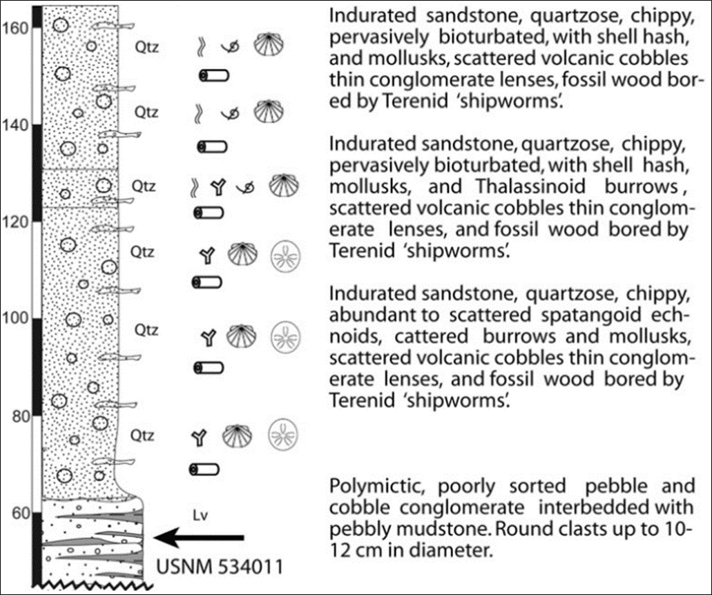
[Figure 2. Section of the Tobabe Sandstone Fm from Uhen et al. (2010). Small Plantain Cay to the Valiente Peninsula, Bocas del Toro (Figure 1 & 2) (9°7’41.00”N, 81°48’36.25”W to ~9°7’11.45”N, 81°49’50.68”W)]
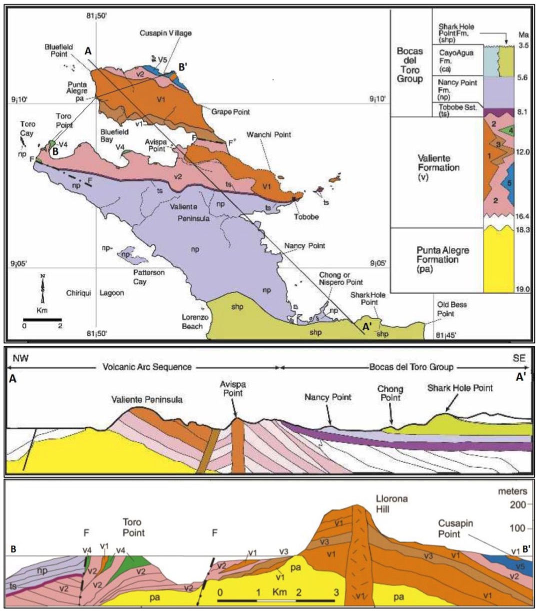
[Figure 3. Coates et al. (2003 & 2005)’s description of the geological map and cross sections (A-A’ and B-B’) of the Valiente Peninsula (Punta Valiente) showing the distribution of the Punta Alegre Fm and Valiente Fm and the Bocas Del Toro Gr. The five lithofacies of the Valiente Fm are indicated by separate colors and numbers on the key (upper right) as follows; v1) basalt lava and flow breccia facies; v2) coarse volcaniclastic facies; v3) pyroclastic facies; v4) coral reef facies; v5) marine debris flow and turbidite facies.]
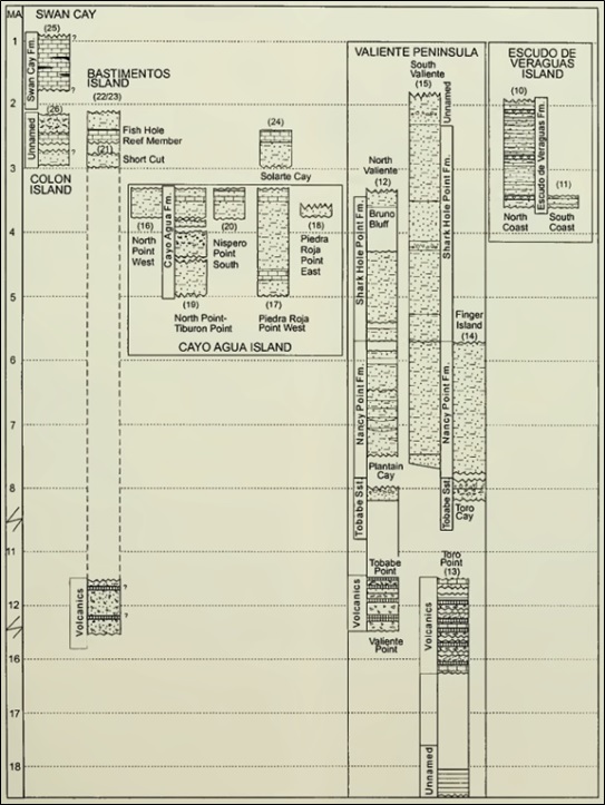
[Figure 4. Correlation of measured sections in the Bocas del Toro Basin. Coates (1999). (Reproduced with permission of the Paleontological Research Institution, Ithaca, New York)]
Relationships and Distribution
Lower contact
Upper contact
Regional extent
GeoJSON
Fossils
Age
Depositional setting
Additional Information
The stratotype (Section 12 of Coates (1999)) is on Small Plantain Cay; a small, unnamed island immediately to the west; and for about one km along the coast, between Tobabe Point and the village of Tobabe. Section 14 of Coates (1999) describes a lateral variation of the Tobabe Fm exposed on the Toro Cays, south of the entrance of Bluefields Bay, at the western end of the Valiente Peninsula